Business Details
27 Years
experience
Your Trusted Partner for Land Surveying Solutions
Precision Geomatics has been a trusted provider of professional land surveying and mapping services since 1999, specializing in the Energy, Construction, and Land Development industries. With offices in Calgary, Edmonton, and Drayton Valley, we serve projects across Alberta, British Columbia, and Saskatchewan. Our team of experienced professionals combines advanced technology with hands-on expertise to deliver accurate, cost-effective solutions tailored to client needs.We offer comprehensive services including pipeline right-of-way surveys, bathymetric studies, line locating, and land development projects. Our commitment to quality control, innovation, and client collaboration ensures timely execution within budget constraints. As a majority Aboriginal-owned company, we uphold values of accountability, integrity, and community engagement while maintaining industry-leading standards through continuous technological advancement.
Services
Land Surveying
Pipeline Integrity Surveys
Bathymetric Surveys
Line Locating
Pipeline Right of Ways
Upstream Exploration Surveys
Wellsite Surveys
Reclamation Surveys
Real Property Reports
Subdivisions
Details
- Year established: 1999
Highlights and features
- We implement advanced cost control systems for accurate budget tracking
- We provide comprehensive QA/QC reports on all construction projects
- Our dedicated Data and Technology team drives continuous innovation
- Our close-knit team ensures quick response times and efficient execution
- We maintain ISO 9001-certified quality management systems
Associations and certifications
- Canadian Association of Pipeline and Utility Locating Contractors (CAPULC)
- Canadian Council for Aboriginal Business
Services
Land Surveying
Our land surveying services combine traditional techniques with modern technology to establish property boundaries, create topographic maps, and support legal documentation. Experienced professionals use GPS and RTK systems to deliver precise measurements for residential, commercial, and industrial developments. We provide reliable data for construction planning, title registration, and regulatory compliance across Alberta.
Pipeline Integrity Surveys
Specialized pipeline integrity surveys utilize advanced survey methods to evaluate pipeline condition and alignment. Our team conducts in-line inspections, visual assessments, and leak detection using LiDAR and GIS technology. These surveys support maintenance planning, regulatory compliance, and risk mitigation for midstream energy infrastructure across Western Canada.
Bathymetric Surveys
Bathymetric surveys use sonar technology integrated with GNSS systems to map underwater terrain. Our services support pipeline routing, flood mitigation, and infrastructure planning by creating detailed 3D models of lake and riverbeds. Applications include volume calculations, spill response planning, and bridge construction assessments throughout Alberta.
Line Locating
Professional utility locating services identify underground pipelines, power lines, and infrastructure using electromagnetic detection and ground-penetrating radar. Our certified crews ensure safe excavation practices for construction projects in Edmonton, Calgary, and surrounding regions. This prevents damage to existing utilities while maintaining project timelines and budgets.
Pipeline Right of Ways
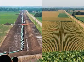
Comprehensive right-of-way surveying supports pipeline development from initial routing through construction and maintenance phases. Our services include regulatory mapping, boundary resolution, and construction staking using LiDAR integration. We ensure compliance with environmental regulations while maintaining accurate documentation for pipeline operators across Western Canada.
People
Darren Eklund
President
President since 2018, Darren leads with 20+ years of industry experience, focusing on strategic growth and operational excellence while maintaining client relationships and technical standards.
Roy Devlin
Former President
Founding leader who established company foundations in 1999, now guiding corporate strategy through board-level advisory roles while mentoring leadership teams across Alberta operations.
Chad French
Senior Manager
Manages complex survey projects with 15+ years of field and office experience, specializing in energy sector challenges while ensuring technical accuracy and client satisfaction standards.
Chad Dahlseide
Project Lead
Coordinates multi-disciplinary teams for large infrastructure projects, combining technical expertise with practical field knowledge to optimize survey workflows and deliver reliable data solutions.
Mike Kim
Technology Director
Drives technological innovation by integrating LiDAR, GIS, and photogrammetry systems to enhance survey accuracy and efficiency across all service lines in Western Canada.
Questions
What industries do you serve?
We primarily serve energy, construction, and land development sectors with specialized surveying solutions across Alberta and Western Canada.
Are you certified Aboriginal-owned?
Yes, we became Canada's first majority Aboriginal-owned professional survey company in 2022 through certification by the Canadian Council for Aboriginal Business.
What technology do you use?
We employ LiDAR, RTK GPS, GIS mapping, and bathymetric sonar systems to deliver precise survey data for complex projects.
How quickly can you start a project?
With crews strategically located across Alberta, we typically mobilize within 48 hours of project confirmation depending on location and scope.
Do you work outside Alberta?
Yes, we regularly conduct surveys in British Columbia and Saskatchewan, with federal land survey capabilities across Canada.
How do I request services?
Contact our Calgary head office at 877-266-6649 or complete our online form to receive a customized project proposal from our team.
Videos