Business Details
25 Years
experience
Expert Land Surveying Services in Victoria, BC
Polaris Land Surveying has been a trusted leader in the land surveying industry since 2001, delivering high-quality, cost-effective solutions tailored to client needs. Our team of certified professionals specializes in defining legal boundaries, resolving spatial challenges, and supporting projects across British Columbia, from urban developments to remote locations. With expertise in subdivisions, strata developments, and advanced mapping technologies, we combine decades of collective experience with innovative methodologies to address complex surveying requirements.Our commitment to precision, client collaboration, and industry-leading standards ensures reliable outcomes for governments, developers, and individual landowners. By maintaining a dynamic, location-flexible team, we provide personalized service while adhering to rigorous professional and ethical guidelines.
Services
Land Development
Residential Surveys
Mapping
Subdivisions
Strata Developments
Air Space Subdivisions
First Nations Surveys
Reality Capture
Legal Surveys
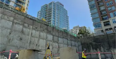
Construction Surveys
Details
- Year established: 2001
Highlights and features
- We have over 40 years of combined experience in land surveying.
- Our team includes certified experts in subdivisions and strata developments.
- We utilize advanced technologies like LiDAR and photogrammetry.
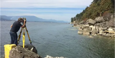
- Our team operates across British Columbia, including remote locations.
- We contributed to the development of British Columbia's Strata Property Act.
Services
Land Development
Polaris Land Surveying provides comprehensive land development services, including subdivisions and infrastructure planning. Our team ensures compliance with municipal and provincial regulations while optimizing land use for residential, commercial, or industrial projects. With decades of experience, we guide clients through complex zoning, re-zoning, and construction layout processes.
Strata Developments
We specialize in strata developments, including bare land and building stratas. Our expertise in British Columbia's Strata Property Act ensures accurate delineation of ownership units and communal spaces. We support projects from initial design to legal registration, addressing challenges like habitable area definitions and public road boundaries.
Air Space Subdivisions
Polaris creates three-dimensional air space parcels for mixed-use buildings, separating ownership of residential and commercial areas. Our surveys define vertical limits and ensure legal clarity for complex developments, leveraging advanced technologies to meet evolving urban planning needs.
First Nations Surveys
We conduct surveys for First Nations communities on reserves and provincial lands, including treaty settlements and infrastructure projects. Our work supports land administration, master leasing, and community mapping, reflecting our commitment to collaborative, culturally sensitive solutions.
Reality Capture
Our reality capture services use LiDAR, photogrammetry, and terrestrial laser scanning to create precise digital models. These technologies support construction monitoring, topographic mapping, and heritage preservation, offering clients detailed spatial data for informed decision-making.
People
Brent Taylor
Senior Land Surveyor
Commissioned as a British Columbia Land Surveyor in 1984, Brent has over 40 years of experience in project management, condominium development, and boundary law. He contributed to the Strata Property Act and specializes in complex legal disputes.
Jordan Litke
Land Surveyor
A BC Land Surveyor since 2011, Jordan specializes in subdivisions, First Nations treaty settlements, and drone-based reality capture. He has led projects in remote and urban settings across British Columbia.
Andrew Christian
Land Surveyor
With nearly 20 years of experience, Andrew focuses on First Nations projects, infrastructure surveys, and legal boundary investigations. He holds commissions in BC, Alberta, and as a Canada Lands Surveyor.
Doug Pearson
Land Surveyor
Commissioned in 2025, Doug specializes in remote-area surveys, construction projects, and topographic mapping. He holds a degree in Geomatics Engineering from the University of Victoria.
Bert Hol
Senior Land Surveyor
A prominent figure in BC since 1984, Bert specializes in high-rise strata developments and air space subdivisions. He served as President of the Association of BC Land Surveyors and led major projects like the Lions Gate Bridge North Tower.
Questions
What services does Polaris Land Surveying offer?
We specialize in land development, subdivisions, strata developments, air space subdivisions, First Nations surveys, and advanced mapping technologies like LiDAR.
Which areas do you serve?
We operate throughout British Columbia, including Victoria, Cowichan Valley, Gulf Islands, Powell River, and remote regions like Atlin and Bella Coola.
How do I start a project with Polaris?
Contact one of our regional team members to discuss your project requirements and receive tailored guidance.
Are your surveyors certified?
Yes, our team includes certified British Columbia Land Surveyors and Canada Lands Surveyors with decades of combined experience.
Can you handle complex legal boundary disputes?
Yes, we specialize in resolving challenging boundary determinations, including natural and rectilinear boundaries.
Do you work on First Nations land projects?
Yes, we collaborate with First Nations communities on treaty settlements, land administration, and infrastructure surveys.