
Business Details
50+ Years
experience
Professional Land Surveyors Serving Manitoba and Beyond
Stevens Surveys is a highly reputable land surveying firm established in 1970, providing geomatics services across Manitoba, Nunavut, and the Northwest Territories. Our expertise lies in cadastral surveying, focusing on legal boundaries of land, water, and air space. With over 40 years of experience, we maintain direct professional control over all projects, supported by a dedicated team trained in innovative technologies like high-definition laser scanning.Certified by Manitoba Land Surveyors (MLS) and Canada Lands Surveyors (CLS), we combine deep legal knowledge with cutting-edge equipment to deliver accurate, timely, and economical solutions for public and private sectors. Our commitment to ethical practices and quality ensures we meet challenges in remote and urban environments while maintaining rigorous professional standards.
Services
Cadastral Surveying
High-Definition Scanning
Subdivision Planning
Geomatics Services
Boundary Staking
Land Title Registration
Construction Surveying
Details
- Year established: 1970
Highlights and features
- MLS & CLS Certified with regional expertise
- 40+ years of land surveying experience since 1970
- Pioneers of high-definition laser scanning in Manitoba
- Direct professional control of all surveying work
- Proven track record in remote and urban environments
Associations and certifications
- Manitoba Land Surveyors
- Canada Lands Surveyors
Services
Cadastral Surveying
Specialized boundary determination services for land, water, and air space. Our team conducts precise boundary staking, title registration, and legal description preparation. Utilizing advanced technologies and deep legal knowledge, we ensure compliance with Manitoba and federal standards while maintaining direct professional oversight throughout all projects.
High-Definition Scanning
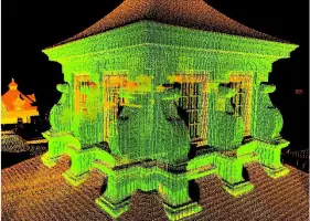
Cutting-edge 3D laser scanning for detailed spatial data capture. This non-intrusive method collects 50,000 points per second with millimeter accuracy, creating comprehensive digital models. Ideal for forensic investigations, construction verification, and historical archiving, it reduces field time by 70% while maintaining unmatched data completeness.
Subdivision Planning
Comprehensive subdivision services from initial consultation to final registration. We prepare Subdivision Application Maps (SAM), conduct boundary research, and coordinate with planning offices. Our process ensures compliance with local regulations and includes steel post placement, final plan drafting, and seamless registration with land titles offices.
Geomatics Services
Advanced geospatial data collection and analysis services. We provide topographic surveys, digital terrain modeling, construction control stakes, and geodetic network processing. Our state-of-the-art equipment supports applications in mining claims, architectural preservation, and infrastructure development projects across diverse environments.
Boundary Staking
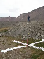
Precise physical boundary establishment services using traditional and modern techniques. Our team locates existing monuments, performs historical research, and employs GPS verification. We specialize in challenging environments, using evidence-based methods to restore missing markers and ensure long-term boundary integrity for landowners.
People
Doug Stevens
Owner & Professional Surveyor
With over 25 years of experience as a Manitoba and Canada Land Surveyor, Doug leads with technical expertise and commitment to quality. He holds a B.Sc. in Survey Engineering from the University of Calgary and maintains direct control over all survey work. His leadership ensures rigorous standards across remote and urban projects.
Questions
What surveying services does Stevens Surveys offer?
We specialize in cadastral surveying, high-definition scanning, subdivision planning, geomatics, boundary staking, and land title registration across Manitoba, Nunavut, and NWT.
Are Stevens Surveys professionals certified?
Yes, our team includes Manitoba Land Surveyors (MLS) and Canada Lands Surveyors (CLS) with decades of combined experience in boundary determination and geospatial analysis.
How does your high-definition scanning work?
We use LiDAR technology to capture 50,000 data points per second with millimeter accuracy, creating detailed 3D models for construction verification, forensic analysis, and heritage preservation.
Can you handle remote location surveys?
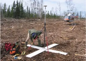
Yes, our team specializes in challenging environments, with extensive experience conducting surveys in Manitoba's remote regions, Nunavut, and the Northwest Territories.
How long does a typical land subdivision take?
While varying by complexity, our streamlined process typically completes field work within days using advanced technologies, with registration usually finalized within 3-4 weeks.
What makes Stevens Surveys different?
We combine 40+ years of experience, MLS/CLS certifications, pioneering technology, and direct professional oversight to deliver accurate, timely survey solutions unmatched in our region.